AlSat-1
The Al-Sat-1 was the first satellite launched as part of a collaboration of several countries to contribute satellites to the Disaster Monitoring Constellation.
Overview
The Disaster Monitoring Constellation (DMC) is an international collaboration of several countries each contributing a satellite to the constellation and sharing the data built by Surrey Satellite Technology Ltd with inputs from our Centre in astrodynamics.
The satellites were to be launched into the same orbit and phased equally around the orbit. AlSat was the first to be launched in late November 2002, the next three satellites were launched in September 2003 and Beijing-1 was launched in October 2005.
The delay between the launches required good modelling of the orbit of AlSat to feed into the launch parameters for the rendez-vous satellites. The success of the DMC mission is reliant on the accurate phasing and constellation acquisition of the satellites which was achieved during 2003-04.
Partners
The original DMC partners were:
- Algeria (AlSat)
- Turkey (BilSat)
- Nigeria (NigeriaSat)
- UK (UKDMC).
A fifth satellite, Beijing-1, was launched by China in 2005.
Launch errors
Due to problems on the upper stage of the launcher, AlSat was inserted into an orbit that was too high. The error in the SMA was about 30 km which not only caused the period to be incorrect, but also led to evolution of the local time at the ascending node. As a result AlSat expended about 17m/sec of its fuel budget to correct the SMA.
Constellation modelling
The constellation modelling had to take account of the Earth’s geopotential, the gravitational influences of the Sun and Moon and atmospheric drag. Radiation pressure forces were very small as the satellites only have a small surface area. The epicycle model was used for the planning as the satellites can determine their epicycle elements onboard from GPS data and this gives a good model for predicting the secular evolution of the constellation.
The epicycle model, however, is not sufficiently accurate to determine the firing ΔV and the timing. For this a full numerical propagator based on the symplectic geometry of the orbital motion was used. As well as this model, the NORAD TLE representation was also used. While this is a less accurate model than either of the other two, it did provide the operators a means of maintenance of the constellation in the absence of GPS data should there be a parts failure.
A nominal trajectory was decided upon based on the user requirements and adapted with simulation of launch and operation scenarios. A priority was to minimise the propellant usage needed for constellation acquisition in order to maximise the life of the mission. A sequence of firings is then determined to optimise fuel usage and bring the satellites into the correct ltan, sma and inclination. This is shown below as a series of jumps in sma to increase the difference from the reference and then decrease it to bring the satellite into correct phase.
The modelling of the constellation requires the propagation of the relative motion between the satellites. When simulating the effects of the firing table the propagation has to be halted at the determined time and the ΔV applied. Propulsion parameters are updated in accordance with the observed effects upon the orbit parameters which then adjusts the firing durations.
Constellation phasing
Once the other satellites were launched in September 2003, AlSat had been brought to within 300m in SMA of the rest of the constellation.

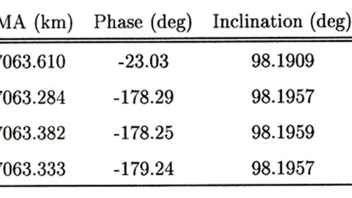
On 27 October 2003 the satellite parameters were as follows.
Changing the reference orbit
Since AlSat had already expended a considerable fraction of its fuel budget, it was decided to change the reference orbit to that of the AlSat satellite. This meant phasing the other three satellites in SMA.
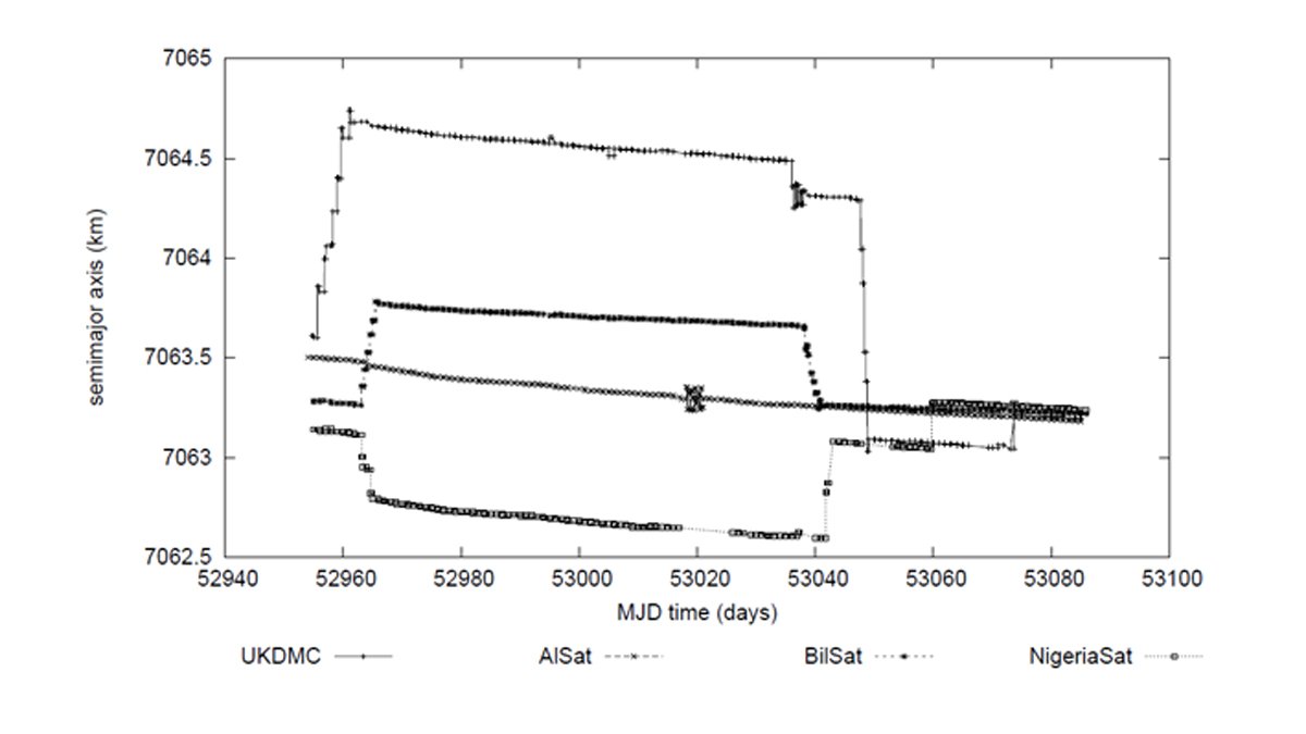
The AlSat satellite starts the third one up. We see from the data that the semi-major axis is decreasing due to atmospheric drag. Nominally this is the same for all the satellites, but it is clear from this plot that there were variations.
The NigeriaSat started with the highest SMA and UKDMC the lowest in this plot. BilSat starts below AlSat but rises above it in the first set of firings. The slope of the decay in sma is shallower for BilSat as this satellite was more massive that the others and so the effect of drag was reduced.

The evolution of phasing the other three satellites in SMA.
Correcting the inclination differences
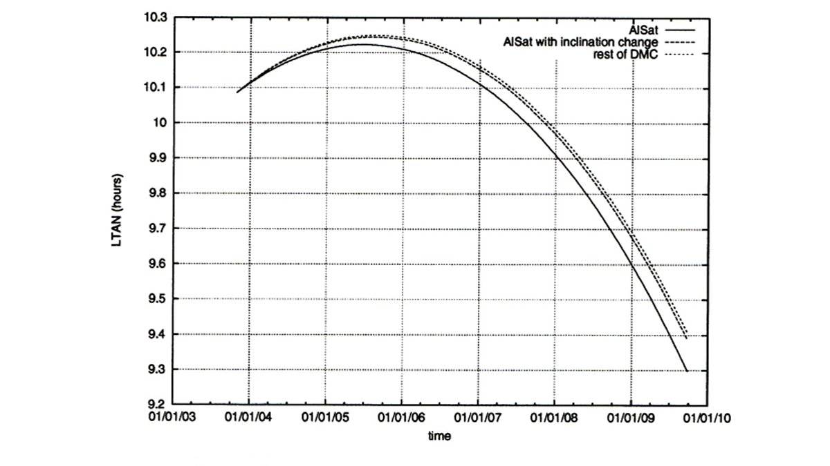
For NigeriaSat and AlSat there were cross-track firings to correct the inclination differences. These appear as a set of bunched changes in the SMA plot at MJD 53020 and 53040. AlSat still had to make cross track firings as otherwise the difference in LTAN would lead to AlSat drifting in ascending node away from the rest of the constellation. This is shown in the figure.
The mission was designed to last five years and the requirement was that all the satellites would be in a 10am sun-synchronous orbit with a 30 minute margin. The plot below shows AlSat leaving this window three months before the end of the mission.
Problems were encountered in the ground station software that interrupted the second stage of firings on NigeriaSat and UKDMC. This can be seen where UKDMC starts to increase its SMA in 53040 (6 February 2004) and then stops. Similarly NigeriaSat starts to drop its SMA and stops just after the inclination corrections.
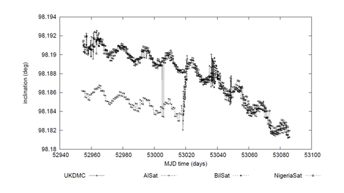
In inclination apart from AlSat that can be seen to join the others on day 53020 (16 January 2004). The spikes in the data are GPS errors rather than estimation errors as no estimator was being run at the time. The periodic oscillation and general decline of the inclination is due to the gravitational attractions of the Sun and Moon upon the satellites.
The cost in terms of ΔV for the satellites for these phasing manoeuvres was:
- AlSat 65.5 cm/sec
- UKDMC 150.9 cm/sec
- NigeriaSat 59.6 cm/sec
- BilSat 47.9 cm/sec.
Publications
- "Modelling and control of relative orbits for spacecraft flying in sormation in LEO" Kormos, T. & Palmer, P.L., 3rd Int. workshop on satellite constellations and formation flying, Pisa, Italy, pp. 279 – 286, 2003.
- "Orbit Acquisition of the Disaster Monitoring Constellation – Preliminary Results" Imre, E., Kormos, T. & Palmer, P.L., 16th Automatic Control in Aerospace Conf, St Petersburg, Russia, June 2004.

